FEMA Quadrant Sign Codes or Tactical Markers/Tacmars
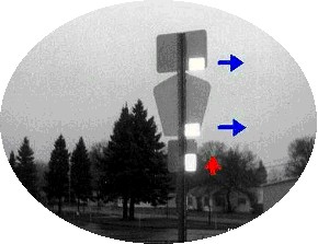
Three tack marks denote a facility symbol.The red arrow up indicates an airlift facility
About ten years ago I noticed reflective stickers popping up on the backs of some of the highway signs in our area of the province. Did some research and found that when followed at night by their reflective quality on the back of the highway signs in the oncoming lane (unless a divided highway) they took me to:
- An old military barrack (now a community/recreation center)
- Numerous train loading platforms outside various towns and cities
- An empty grassy meadow at the top of a mountain
- A bible camp with many cabins and kitchen facilities
Traveling the Trans Canada Highway at night is a fascinating adventure with a little knowledge of the placement of these stickers as directional codes.
Secretly embedded codes like these are part of "Operation Garden Plot" where U.S. forces/National Guard and Partnership NATO/UN military will police and patrol our streets and highways during MARTIAL LAW. Detention areas, and facilities with massive air-lifts are planned to relocate the populace to "safe zones" during a bio/chem or nuclear attack.
A bit of investigative research indicates they are part of a military plan known by several names:
- Operation Garden Plot
- United States Civil Disturbance Plan 55-2
- Operation Cable Splicer
- REX-84
- MACDIS
These coded markers are used to overcome language barriers among allied peacekeepers. They point to old military installations, and to ski resorts, schools, churches, and undeveloped areas which are equipped to become temporary cities in times of civil disturbance or emergency.
Here is a brief explanation of how the quadrant sign code works:
- Signs are divided in half, left and right.
- Markers positioned on the right side, point right.
- Markers on the left side, point left.
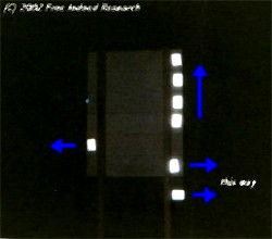
- Markers turned on "end" are an arrow "UP" code, signifying a site for pick-up helicopter airlifts
- Marker on top means straight ahead
- Double ended arrow denotes an airlift facility
- 3 arrows denotes a facility
- 2 arrows denote the direction of the operational site
- The coding on the stickers is also used to point to drugstores with passport photo services. Under martial law, this facility may be used for medical care, inoculation/vaccination, and creation of ID cards.
Tacmars’ are used to encode the following information:
- Directions to closest military installations
- Directions to closest triage or quarantine facilities
- Facilities with Internet access, for the following purposes:
- Communications Identification and/or background search of individuals

Note the triad (3) markers and arrows, which is a confirmed facility symbol, targeting an important site for confiscation. Arrows *UP* denote a pick-up point of some kind, usually airlift/drop zone site
The civil defense purposes of the US Interstate System are no less believable than TACMARs. And some folk out there say that these markers are used to date the signs, with many signs needing half a dozen or more date stickers.
Newsbit:
Naval Chief Petty Officer Testifies Of Tacmars during Tour of Duty in Middle East
'While I was stationed in Beirut, Lebanon after the bombing in the 80's, I saw those markers (tacmars) put on the back of their road signs to bridge language barriers among multinational peacekeepers doing military operations in the city.' (CPO A. Phillips U.S.N.)
Some links to get your research started: